
Preliminary analysis shows that between 1998 and 2023, more than 1,341 hectares (3,314 acres) within Buenaventura’s current boundaries transitioned from pasture to regenerating vegetation. That represents 30% of the more than 4,400 hectares (11,100 acres) in the reserve today. While this figure includes a mixture of ages of recovering secondary forest, it reveals a remarkable transformation: land that was once dedicated to cattle ranching is becoming cloud forest again.
The Buenaventura Reserve is located in El Oro Province in southwestern Ecuador where the humid Chocó meets the dry Tumbesian region. This transition zone is one of the most biodiverse and unique landscapes in Ecuador. Yet much of this biodiversity was at risk, as cattle ranching, agriculture, mining, and human settlement expanded across the region. Large areas of cloud forest were cleared, wildlife populations became increasingly isolated, and ecological connectivity across the landscape was progressively lost. There are no national parks in the region protecting those forests. Today, approximately 70% of El Oro’s original vegetation cover has disappeared.
Jocotoco created the Buenaventura Reserve to protect the region’s threatened biodiversity, but protecting isolated forest fragments would not be enough. Many species, especially birds and mammals, move across large territories and elevational gradients in response to seasonal food availability and changing environmental conditions. Protecting these species therefore required protecting, restoring, and reconnecting the broader landscape.
Over the years, Jocotoco strategically expanded the reserve by acquiring former cattle pastures and securing key properties adjacent to remaining forest patches. Once grazing pressure was removed and forests were protected, recovery began. In many areas, native vegetation returned naturally, while in others we planted thousands of native trees to accelerate regeneration and reconnect critical habitat corridors.
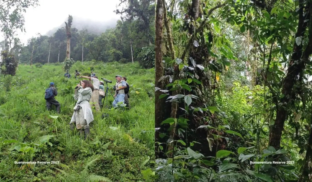
Photos from the same location in Buenaventura, one from 2003 and one from 2025, show the recovery of forests in just over two decades.
The Buenaventura Reserve and its recovering forests sustain high levels of biodiversity. In total, Buenaventura supports at least 514 species of birds, 62 mammals, 44 amphibians, 68 reptiles, and 769 plants. This includes 79 species that are either Critically Endangered (8), Endangered (29), or Vulnerable (42).
Monitoring programs that combine bioacoustics, camera traps, and artificial intelligence have documented threatened species using recovering habitats throughout the reserve. This includes the Endangered El Oro Parakeet (Pyrrhura orcesi), El Oro Tapaculo (Scytalopus robbinsi), and a tree frog called Dendropsophus gryllatus. It also includes Vulnerable species such as the Long-wattled Umbrellabird (Cephalopterus penduliger), Cloud-forest Pygmy Owl (Glaucidium nubicola), Ochre-bellied Dove (Leptotila ochraceiventris), Rufous-headed Chachalaca (Ortalis erythroptera), Mantled Howler Monkey (Alouatta palliata), and Chimbo Rocket Frog (Hyloxalus infraguttatus). For many of these threatened species, Buenaventura serves as one of their most important refuges in Ecuador, and in some cases, their only protected habitat.
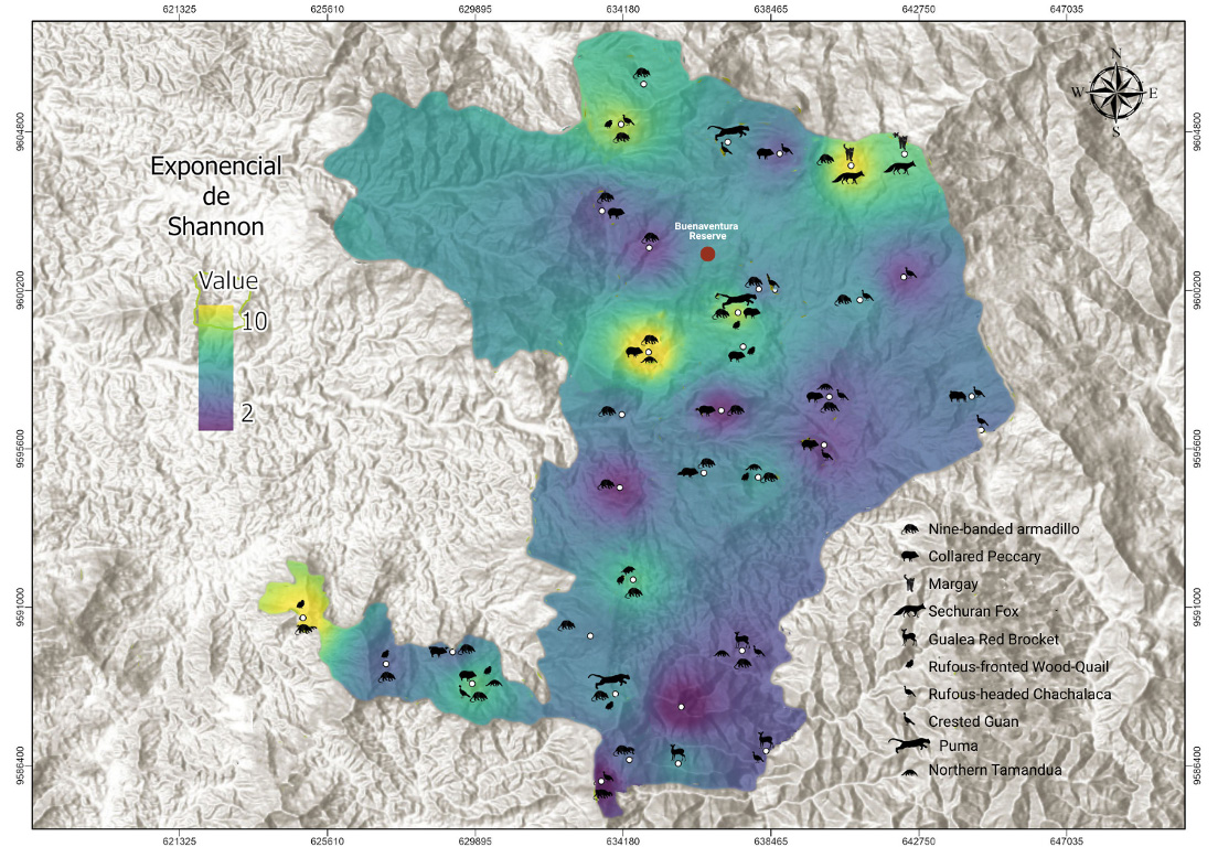
This map show biodiversity levels in and around the Buenaventura Reserve. Lighter colors represent higher biodiversity and darker colors represent lower biodiversity. Wildlife identified by our camera traps are shown as icons on the map.
While these findings already reveal remarkable recovery at Buenaventura, they are only the beginning of Buenaventura’s conservation story. Our goal is to expand the reserve from more than 4,400 hectares (11,100 acres) today to 7,400 ha (18,200 acres) by 2033. We must expand the reserve upslope to allow wildlife to move farther up in elevation as climate change pushes their cloud forest habitat upslope. Much of the land we will purchase has already been cleared for cattle grazing, but like other previously cleared lands in Buenaventura, those forests will regrow over time.
Join us and lead the next phase of Buenaventura’s conservation story by donating, here.